6/18 - Hiking the Rim to River Trail in the Grand Canyon
After training for a few months, it was time to see if all my hard work would pay off or if I would die in the heat of the Grand Canyon. The original plan was to hike North Rim to South Rim of the Grand Canyon but the years heavy snowfall caused a landslide on the North Rim knocking out their power and water supply. So, we had to adapt the plan and decided to do the Rim-to-River trail instead. Although this trail was 6 miles shorter, it still had the rigorous climb up the South Rim Grand Canyon wall. We picked descending on the South Kaibab Trail until the Colorado River then following the river to Phantom Ranch before climbing back up on the Bright Angel Trail. We picked this order since the water stations were turned on only on the South Kaibab trail so we thought we could carry enough water for the descent but would need to refill more during the ascent. We ended up choosing correctly.
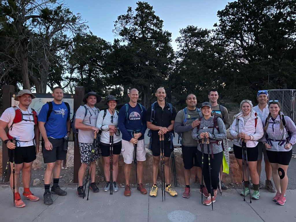
We drove out the day prior, on Saturday, to settle in to our hotel, get the lay of the land and relax a bit before the big day. We were going out with a group of 14 so we car pooled with our friend Brent and stopped at our favorite place for lunch to carb load - Panda Express. After lunch and a quick bathroom break, we continued our drive and arrived in time to meet the group for dinner at a place called We Cook Pizza and Pasta. Nina and I split a pizza to keep the carb loading going. Then, we decided to catch the sunset over the Grand Canyon and headed to the overlook. I couldn't find parking so we missed the sunset by only a few minutes but were still able to steal a glance at the trail we'd be hiking tomorrow. Once we settled into our hotel for the night, we called it an early bedtime since we had an early wake up for the big day!
Hike day! We woke up at 4:00 to be at the trailhead by 4:30 to get started right as the sky was lighting up. Nina wasn't hiking so she took two trips driving everyone from the hotel to the trailhead at South Kaibab. I had planned on bringing my headlamp but decided I didn't need it so put it back in the car. I said bye to Nina armed with my 3.0 liter water bladder, 7 uncrustable sandwiches, some sunblock, 6 LMNT salt packets and 2 trekking poles. I was ready!
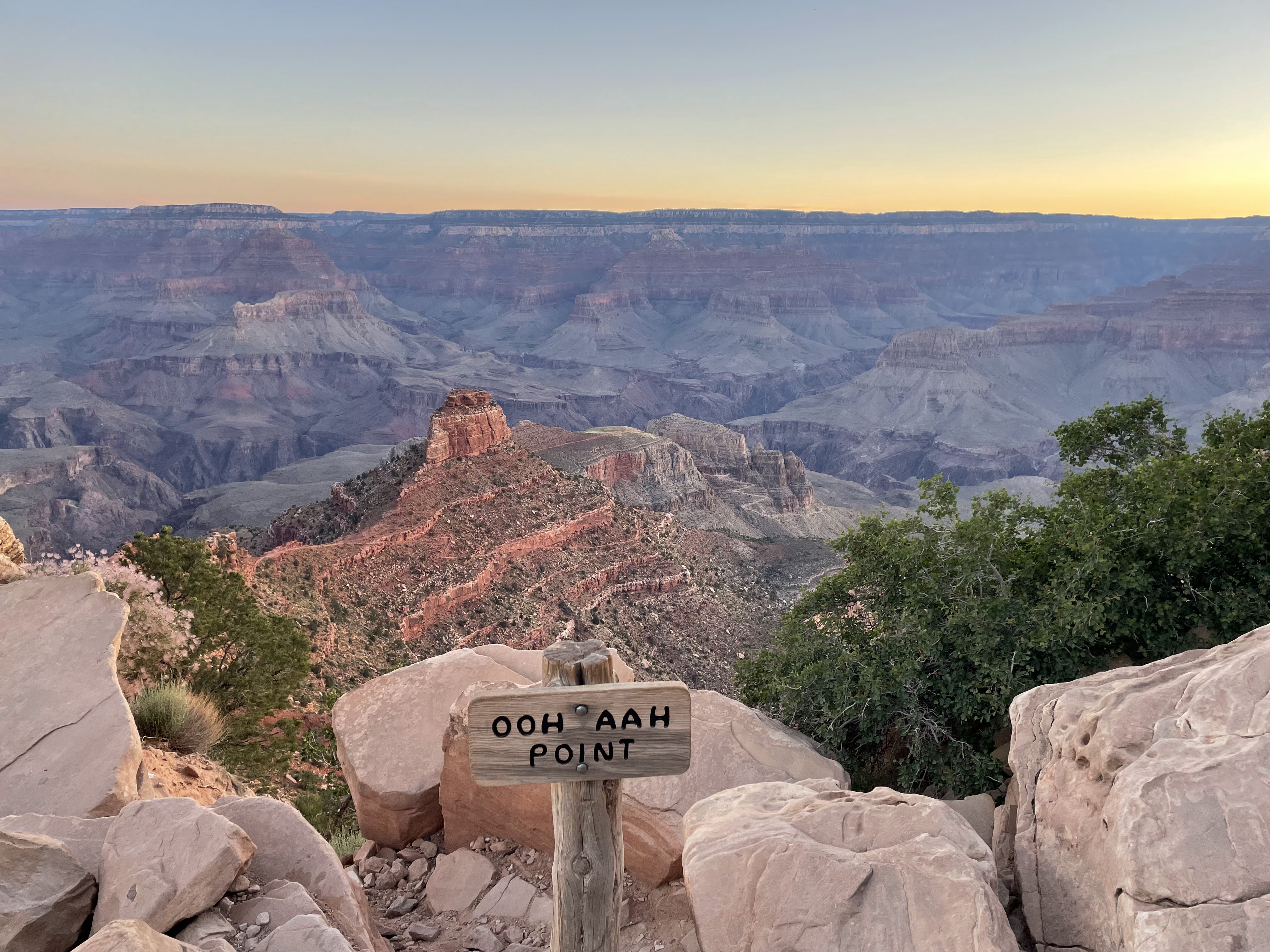
As we started our descent, our first big view point was the Ooh Aah Point which offered great views of the entire Grand Canyon. We could even see where the North Rim trail would have taken us if it was open. I've read online that some people just hike to this point and turn around and head back up and I can see why. What made it even better was that the sun hadn't crested over the canyon walls yet so there were no shadows. This scenic overlook did not disappoint!
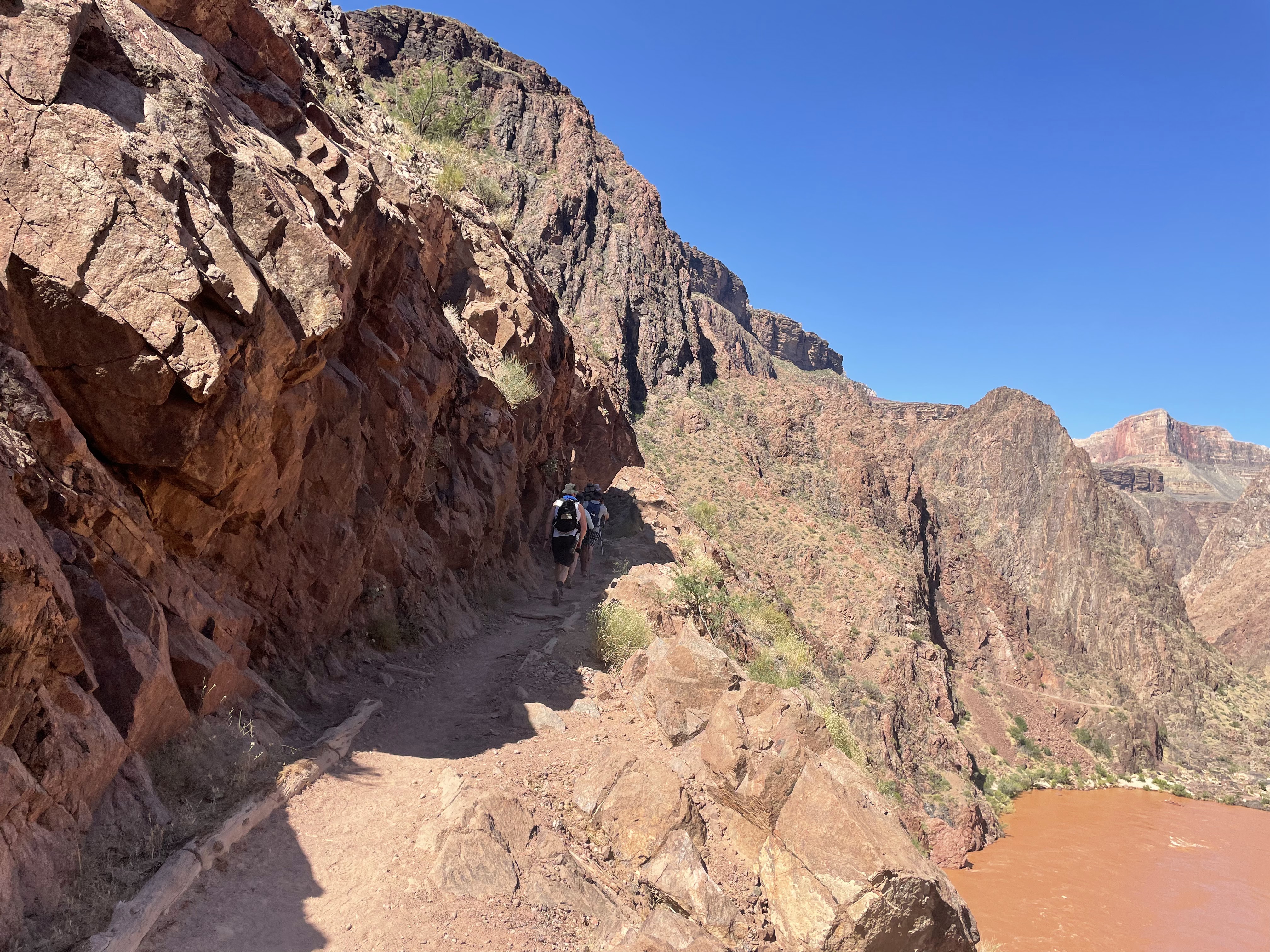
During our descent, we passed Cedar Ridge and Skeleton Point. Although we didn't see any mules, you could see their hitching posts at all the major stops. Then, about an hour in, the trail started to hug the canyon wall as we were getting closer to the bottom. This was cool because you couldn't hear the person in front of you the second they went around the bend even if they were only 10 feet ahead. It made you really appreciate how big the Grand Canyon was and how remote you truly were.
About 2.5 hours in and we came to a tunnel into the bridge that crossed the Colorado River. I used my Garmin inReach to text Nina my location while I was in the center of the bridge intentionally to get her to think I was in the river. I chuckled to myself as I finished crossing it. I found out later she thought I had fallen in the river until she zoomed in on the map and saw the bridge. Gotta enjoy the little things!
This was also the first time in 7 miles that the trail was flat. It was a stark reminder of how much altitude we had to climb once we started our ascent. But, for now, it was time to enjoy the views of the river as we pushed forward to Phantom Ranch for our first and only stop.
Not long after the bridge, we arrived at Phantom Ranch. This is the only sign of civilization along the hike and is a campground that's almost always full, where the park rangers live, and is complete with a little store. The store opens at 8:00 everyday and we arrived at 8:00 right on schedule. It took us approximately three hours to descend and arrive here. We took a 30 min break to eat some snacks, hit the bathroom, top off our water, and buy some merch! I love merch so I bought a sticker for myself and a hat for Nina. You would think that she would like the hat since I carried it for 11 miles and over 4,600 feet of ascent but she doesn't wear it. In her defense, it's pretty ugly but options are pretty slim when all the merch is carried in by mule. It's the thought that counts right? By the time we departed around 8:40, it was already pushing 100 degrees outside.
After Phantom Ranch, we had 3 relatively flat miles to hike along the river to get to the Bright Angel trailhead turn off where we would start our ascent. Although we stayed together clumped up on the descent, the group started to split up at each person's own pace once we started the climb. As someone who doesn't do much cardio with short legs, I found myself near the back of the pack. But that's okay, it wasn't a race against each other so much as it was a race against the heat. I didn't want to be low elevation when the heat of the day set in. Slow but steady!
Phantom Ranch was the last water station until the 4.5 miles remaining station so we had about 3 uphill miles to go with just that water. It turned out to be more than enough as this initial climb wasn't as steep as some of the later sections.
At the 4.5 mile remaining station, I topped off some water and had another uncrustable. I didn't stay for long since the day was definitely heating up so I decided to press on.
Before the 3 mile remaining station, the trail was straight forward with only a slight upslope until I arrived at the canyon wall then it all changed into switchbacks that were exposed to the sun and quite steep with a lot of stairs to prevent erosion. I was feeling pretty good until that point. My heart rate was in the 160s during my climb to the 3 mile remaining station. I filled up water, had my last uncrustable, and dosed my hat in water to help cool off since my body was getting pretty warm. My heart rate dropped by 20 beats a minute once I dosed my hat. The big mistake here was that I didn't dose my shirt as well as my hat to really help my body cool off. Nina texted me saying that she was going to wait for me at the 1.5 mile remaining station so off I went with the end in sight!
The distance between the 3 mile and 1.5 mile remaining station was where it got real. I had plenty of water and one packet of salt left so I wasn't concerned about heat exhaustion/stroke but I was still really struggling to keep moving. My heart rate during this 1.5 mile stretch was consistently high 170s to low 180s. This stretch was nothing but sun-exposed switchbacks with more stairs. So many stairs. I was able to find one shady spot by leaning up against the wall. While trying to cool off there, a friendly squirrel hopped up on a log to see what I was up to before hopping away. When I fully climbed up into the 1.5 mile remaining station, I was out of uncrustables, sunblock and I felt I was getting pretty sunburnt. Needless to say, morale was low at this point.
I was very happy to make it to the 1.5 mile station to find Nina waiting there with more sunblock and snacks! I spent about 30 minutes cooling off in the shade and getting my salt levels back up. At Nina's recommendation, I dosed my shirt at the water station which immediately cooled off my body. My heart rate went from 175 to 130 within seconds. I really underestimated how much of a load it took to keep my body cooled off. I gave Nina the hat I had been carrying for hours and she put it on for our one and only selfie.
The last 1.5 miles went better than the previous 1.5 miles since I wasn't overheating anymore. However; I felt I was getting a little hypoxic as the trail ended at 7,200 feet. But I sucked it up and gutted it out with Nina by my side. Once complete, we took a group shot at the top before heading back to our hotel rooms for a shower then meeting up at a local Mexican place for a well deserved burrito and Margarita.
As expected, I was feeling pretty tired that night so I slept from 7PM to 7AM logging 12 hours of sleep straight. It was great! Nina, Brent and I departed the area pretty early so we could get back since Lou and Noah were coming into town to stay with us for a hockey tournament and we wanted to see them.
Overall, the hike was 17.9 miles with 4,692 feet of ascent and took me 10 hours and 9 minutes. Our friend Will did a fantastic job setting up the trip. Despite the challenge, it was a great hike that I'd love to do again!
Wow - what a hike! Congrats to you for completing it …. Looks like you were well prepared for it 😁 Love the graphic recap of your trek with all the captions & pictures. And I thought Nina’s hat was very cute! 😂


Wow - what a hike! Congrats to you for completing it …. Looks like you were well prepared for it 😁 Love the graphic recap of your trek with all the captions & pictures. And I thought Nina’s hat was very cute! 😂
ReplyDelete